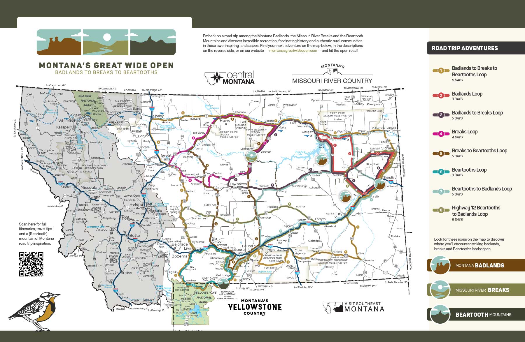
Over the course of five days, travel from Montana’s northern reaches, where the enchanting breaks of the Missouri River cut through wide-open high plains, to the south, where the iconic Beartooth Mountains straddle the border with Wyoming. Along the way, discover multifaceted Montana history — dinosaur fossils, Native American sites, Lewis and Clark Expedition sites and places of early military and homestead settlement — within welcoming prairie and mountain towns and stunning landscapes. Enjoy world-class recreation at every turn as well, from invigorating hiking and biking, to thrilling hunting and fishing, to unparalleled wildlife watching. Buckle up and head out on a voyage of Montana discovery.
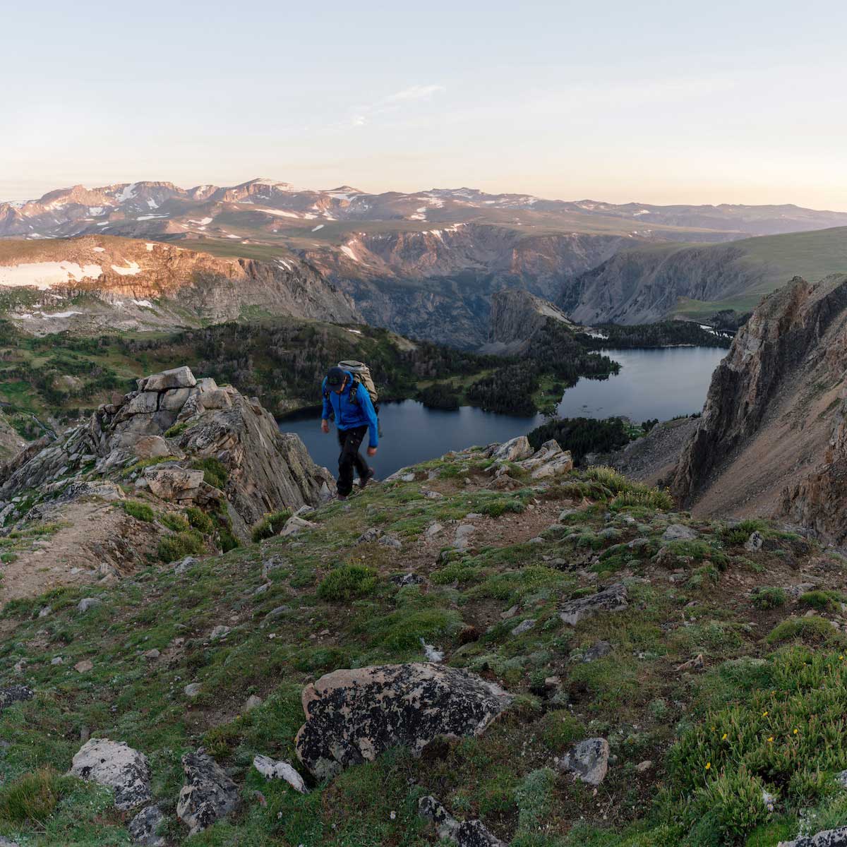 Jeff Bartlett
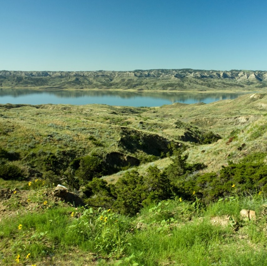 Rick Graetz
 Jordan Lefler
You couldn’t ask for a better place than Fort Benton — known as “the birthplace of Montana” — to start a trip that offers so many encounters with Montana history. Fort Benton was established in 1846 — more than 40 years after Lewis and Clark traveled through the area — and is the oldest continuously occupied settlement in the state. First a fur trading post and later a military post, a boisterous river port where steamboats docked and a destination for homesteaders ready to start new lives, the town is a National Historic Landmark recognized for its role in the opening of the Northwest and western Canada to settlement.
Delve into the area’s storied history starting with a tour of Historic Old Fort Benton, which, in the 1850s, was an important site of the fur and buffalo robe trade. Today, see preserved and reconstructed fort structures — including the trade store, warehouse and blacksmith and carpenter’s shop — staged with period furnishings and trade goods. Explore the Fort Benton Museums and Heritage Complex, an impressive group of museums and sites that together share a comprehensive picture of the region’s past. Another of Fort Benton’s gems of Montana history is the Grand Union Hotel, the oldest operating hotel in the state. When it opened in 1882, it was called the finest hotel between St. Louis and Seattle. A meticulous restoration has returned it to its original grandeur and today, guests will enjoy a warm welcome both at the hotel and at the hotel’s farm-to-table restaurant, the Union Grille.
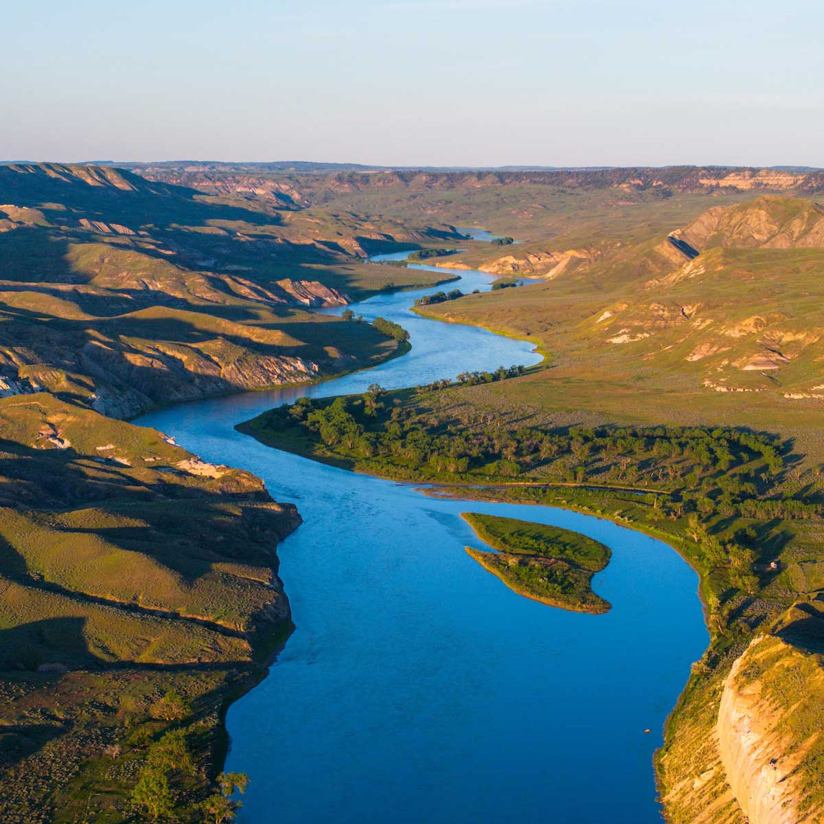
Fort Benton also marks the start of the Upper Missouri River Breaks National Monument — and many folks’ adventures upon it. “The Breaks,” as it’s known locally, stretches 149 miles from Fort Benton on U.S. Highway 87 to U.S. Highway 191 where the Fred Robinson Bridge crosses the river. The monument encompasses the terrain paralleling the Upper Missouri National Wild and Scenic River — water and land that hold Native American, Lewis and Clark and homesteader history and provide unrivaled recreational opportunities including float trips, hiking, camping, wildlife viewing, fishing and hunting (Fort Benton is home to many outfitters than can help facilitate Breaks excursions). As the name suggests, the landscape is quintessential breaks topography — higher country that “breaks” into steep slopes, canyons and ravines where it meets the river. To learn more about the natural and cultural history of the Breaks, be sure to visit the Upper Missouri River Breaks National Monument Interpretive Center, part of the Fort Benton Museums and Heritage Complex.
From Fort Benton, drive northeast on US-87 to Big Sandy, an agricultural community and trade center situated among hilly wheat fields near the Bears Paw Mountains to the east. Check out the collection of early pioneer photographs — the largest in Choteau County — at the Big Sandy Historical Museum before embarking on an out-and-back side trip into the Breaks monument itself. Take Route 236 southeast from Big Sandy and head toward the town of Winifred on the other side of the Missouri. The road, which is mostly gravel, traverses rugged prairie and follows the path of the river, delivering views of the stunning topography that defines the Breaks. Keep an eye out for the White Cliffs, striking white sandstone formations that earned specific mention from the Lewis and Clark Expedition. They hug the water’s edge over a 46-mile stretch from the Virgelle area to Judith Landing, where you’ll cross the river and continue on Route 236 to Winifred, a rural town situated within a picturesque mix of sweeping prairie land, timbered canyons and rugged breaks. The deer, antelope, elk and bighorn sheep that roam this landscape and the upland birds that inhabit the prairie draw both wildlife watchers and hunters here.
Head back the way you came and at Big Sandy, take US-87 northeast once again. Turn east when US-87 runs into U.S. Highway 2, the northernmost east-west road crossing Montana. This stretch of highway, together with the rail line it parallels and the towns and landscape along them, is known by locals as the Hi-Line. A short drive will bring you to Havre, a rural agricultural community and railroad town that sits near both the Rocky Boy’s Indian Reservation and Fort Belknap Indian Reservation in a landscape of wheat fields and prairie, with the Milk River to the north, and the Bears Paw Mountains to the south. On the northern slopes of these peaks, you’ll find 10,000-acre Beaver Creek Park, the largest county-owned park in the nation, and its abundant recreational opportunities: camping, fishing, hiking and bird watching in summer, ice fishing, skiing, snowshoeing and sledding come winter and epic stargazing all year round — the park is a Trail to the Stars site. And speaking of winter, Bear Paw Ski Bowl, nestled in the heart of the Bears Paw Mountains, is a little-known but beloved ski hill that is a favorite spot for locals to ski both downhill and cross-country.
Havre’s roots lie in the establishment of Fort Assinniboine in 1879: Traders were drawn to the fort, soon leading to formation of a small town that grew — particularly after 1890, when the Great Northern Railroad arrived — into Havre. Today you can tour Historic Fort Assinniboine, which was one of the largest forts built in the U.S. and constructed expressly to protect against attacks from Native American tribes living in the region, particularly the Sioux Indians. Of the forts in Montana, it has the most original buildings still standing. In town, explore the Havre of yesterday at Havre Beneath the Streets, a tour of the underground spaces that housed various Havre businesses — a honky-tonk, opium den, restaurant and bordello among them — while the community was rebuilt following a city-wide fire.
There are opportunities to explore area history that reaches back further than the 1800s, too. In addition to more recent area history, the H. Earl Clack Memorial Museum — a Montana Dinosaur Trail site — features an exhibit of 75-million-year-old dinosaur eggs and embryos found nearby in the Judith River Formation as well as a cast of a skull from the rare Stygimoloch. The museum also manages the Wahkpa Chu’gn Buffalo Jump (pronounced WALK-paw CHEW-gun) — a true archaeological treasure. Used extensively by Native Americans over the last 2,000 years as a kill site as well as a campsite, the buffalo jump features exceptionally well preserved faunal layers that extend up to 20 feet below the surface and has been excavated in such a way as to leave artifacts exposed in the exact places they were left.
Leaving Havre, take to the Hi-Line for the 30-minute drive east through the Milk River Valley to Chinook. On the 500 block of Chinook’s historic main street, visitors will find Blaine County Museum. The museum, a Montana Dinosaur Trail stop, features hadrosaur, gorgosaurus, and edmontonia fossils from the Judith River Formation as well as remains of gigantic marine reptiles — mosasaur and plesiosaur — and invertebrates from the area, once covered by an ancient ocean. Other museum exhibits feature historical, early 20th-century photographs of the Aaniiih (Gros Ventre) and Nakoda (Assiniboine) people of Fort Belknap and artifacts from the early days of local ranching and homesteading. Chinook was once the stomping grounds of Montana’s famed cowboy artist Charles Marion Russell, and Blaine County Museum boasts a small display of CMR originals. The museum is a partner of the National Park Service and distributes NPS trail guides and other literature related to Bear Paw Battlefield — the site where the harrowing Nez Perce Flight of 1877 came to its dramatic close. On Oct. 5, following a five-day battle with elements of the U.S. Army led by Col. Nelson A. Miles, Chief Joseph delivered his immortal surrender, “From where the sun now stands, I will fight no more forever.” Museum visitors will find exhibits displaying artifacts found at the battle site and time-period photographs, as well as the 20-minute documentary "Forty Miles from Freedom." Bear Paw Battlefield itself is located 16 miles south of Chinook.
A block from Blaine County Museum, visitors can experience Blaine County Wildlife Museum. Arguably one of Montana’s greatest hidden gems, the museum features world-class wildlife displays, spotlighting native species in painstakingly detailed representations of their natural habitats. A visit here serves as a kind of preview of the wildlife you might spot in refuge lands near Malta, a community about an hour’s drive east on US-2. Malta offers exceptional access to wildlife-centric recreation — even Lewis and Clark commented upon the abundance of animals here when they traveled through the area in 1805. Close by are the Charles M. Russell National Wildlife Refuge and the Bowdoin National Wildlife Refuge — a Missouri River Country Talking Trail Talking Point — both of which provide chances for deer, antelope, elk and upland game bird viewing and hunting in pristine wilderness. Fishermen will find opportunities to catch walleye, paddlefish, trout and other species at the nearby Milk River, Nelson Reservoir — another Talking Point on the Missouri River Country Talking Trail — and even local ponds.
Interested in wildlife of the prehistoric variety? Malta has you covered there, too. The town boasts two museums that are stops on the Montana Dinosaur Trail and the Missouri River Country Talking Trail : the Great Plains Dinosaur Museum and Field Station and the Phillips County Museum. The Great Plains Dinosaur Museum features a wealth of fossils, from plants, turtles and crocodiles to Jurassic and Cretaceous dinosaurs including triceratops, stegosaurus and the horned Maltaceratops. A real treasure here is “Leonardo,” a mummified duck-bill Brachylophosaurus canadensis so well-preserved that fossilized skin covers the body. At the Phillips County Museum, see a 33-foot-long, 95% complete Brachylophosaurus along with other dinosaur fossils and get a sense of Malta’s more recent history through exhibits on Native Americans, cowboys and outlaws, and pioneer life and through the historic H.G. Robinson House: a mail-order home that was originally constructed on the prairie in 1898 and now sits on museum grounds.
Start the day heading southwest on US-191 from Malta. Soon enough you’ll spot your destination in the distance: the Little Rocky Mountains — or Little Rockies, as they’re affectionately called. This group of buttes — Antoine Butte is the tallest at 5,720 feet — rises abruptly above the plain and can be seen from 75 miles away. For communities in the area, including Malta, the Little Rockies are a treasured landmark. Nestled in the Little Rockies is Zortman, a historic gold-mining town — in 1904, its Ruby Gulch mine produced as much as $14,000 per day in bullion. You can learn more about Zortman’s days gone by on the Missouri River Country Talking Trail app. Today, visitors here will find a picturesque village — a simple but elegant white clapboard church sits above town on a grassy mountainside, overlooking the town’s architectural mix of log cabins, miner’s shacks and more modern buildings. They’ll also find that it’s a great base for hiking, hunting, camping, trail rides and gold panning in the Little Rockies.
Back on US-191 heading southwest, keep an eye out for the intersection near mile marker 109. A left on the road leads to UL Bend National Wildlife Refuge, a remote area that’s part of the Charles M. Russell National Wildlife Refuge Complex — this “refuge within a refuge” is surrounded on three sides by both the 1.1-million-acre Charles M. Russell National Wildlife Refuge and the Fort Peck Reservoir. UL Bend offers great opportunities for wildlife watching as it provides protection for an array of species, including eagles, owls, bighorn sheep, black bear, elk and bobcat. Note that the road to the refuge can be quite rough — be sure to check weather and road conditions before visiting.
Continuing southwest on US-191, there is a turn off into the Charles M. Russell National Wildlife Refuge and a self-guided auto tour with interpretive signage — it’s also a Talking Point on the Missouri River Country Talking Trail — that gives an up-close look at the refuge as it leads to the Slippery Ann Wildlife Viewing Area. In September and October at dawn and dusk, you can observe the large numbers of elk that congregate in this spot during the rut (breeding season) — recent records document up to 500 animals gathering — and at night year-round, you can see a sky full of stars at this Trail to the Stars site. From the viewing area, the gravel road will lead back out to US-191, now fully in a breaks landscape. Turn south and cross the Missouri River via the four-span steel girder Fred Robinson Bridge that marks the end of the Upper Missouri River Breaks National Monument and is itself on the National Register of Historic Places. On the south side of the bridge is the James Kipp Recreation Area — a Talking Point on the Missouri River Country Talking Trail and a Trail to the Stars site — which provides convenient river access for fishing or putting in or taking out watercraft as well as a campground with scenic river views.
Bid the Missouri River goodbye for now and drive straight south into vast prairie land. Stop at Lake Mason National Wildlife Refuge, a tranquil spot for wildlife watching, photography and hunting, before driving just eight more miles to reach Roundup. The town sits surrounded by hills along the Musselshell River – a great spot for catching trout and catfish or collecting mussels known as “the jewels of the Musselshell.” The hills secured the town’s destiny as an ideal location for ranchers to round up their cattle — a heritage that’s memorialized in a sculpture at the town’s courthouse of cattle crossing a river during a traditional roundup. Stop at the Musselshell Valley Historical Museum to explore Roundup’s cowboy and ranching history and to learn more about life in the valley from the time of the dinosaurs to the days of coal mining and homesteading. Stretch your legs a bit along the Roundup RiverWalk, which skirts the Musselshell River, and don’t miss the standout barbeque and in-house baked goods at The Backporch, a James Beard Award finalist. Prepared with many local ingredients and a healthy amount of tradition, it’s ultimate comfort food done the Montana way. If you’re in more of a burger mood, head to The Grand — another Southeast Montana Burger Trail stop — and enjoy a warm cowboy welcome to boot.
Making your way to Billings from Roundup on US-87, you’ll pass through craggy terrain before you cross the Bull Mountains and enter an expansive prairie landscape. The road passes near Acton Recreation Area, which is worth a side trip. Here, opportunities to mountain bike, hike, hunt (in season) and watch wildlife among sandstone bluffs, minor badlands and steep drainages abound. Camping is allowed, which is handy because the lack of city lights makes it an incredible spot for stargazing — in fact, it’s another stop on Montana’s Trail to the Stars.
Farther south in Billings, nestled in the Yellowstone River valley, there’s much to explore in and around town, thanks to its vibrant downtown, museums, historical sites and opportunities for outdoor recreation. Visit the Yellowstone County Museum, the Moss Mansion Museum or the Western Heritage Center to familiarize yourself with the history and the inhabitants of the landscapes you’ll see in the days ahead. Time it right and catch one of the Western Heritage Center’s Hoof It with a Historian walking tours of historic Billings locations — you may encounter the Northern Hotel, a fixture of downtown Billings since 1904. Its current building — constructed in the early 1940s after its original structure was destroyed in a fire — was thoroughly renovated and updated in 2013. East of Billings, experience turn-of-the-20th-century farm life at the Huntley Project Museum, which tells the story of an innovative U.S. Army Corps of Engineers project to bring water to the dry farmlands of eastern Montana and the towns and homesteads it created through artifacts, farm equipment and historic structures on its 10-acre campus.
If Montana inhabitants of the furred and feathered variety are more your speed, head to ZooMontana, where you’ll see bison, grizzly bears, grey wolves, bald eagles and red-tailed hawks as well as some other species from the 45th parallel. At the Yellowstone Art Museum, let historic and contemporary artwork primarily by artists in the American Northwest inspire you, or take your own tour of the public art found throughout downtown. Take in the impressive overlook views of Billings and the scenery beyond from Swords Park, Zimmerman Park and the 3-mile-long, multi-use Skyline Trail that connects them along the Rimrocks — or “Rims” as they’re locally known. These sandstone outcroppings, the prehistoric river's edge, form a distinctive feature from which you can see the entire city, including six mountain ranges on a clear day. Nearby, Four Dances Natural Area just outside of town affords wildlife watching and hiking opportunities along the way to Pictograph Cave State Park, where you can view rock paintings and artifacts left behind by prehistoric hunters 2,000 years ago.
If you’ve worked up an appetite, check out one — or all three (we know a person on a mission when we see one) — of Billings’ Southeast Montana Burger Trail stops: Diamond X Beer Co., The Burger Dive or Stacked | A Montana Grill. You’ll find two more fun ways to explore Billings and its food and drink offerings in Trailhead Treats and the Billings Brew Trail — trails that lead to establishments in town that will satisfy any sweet tooth or craft beverage craving.
When you’re ready to leave the Billings area behind and start making your way to the majestic Beartooth Mountains, head west to Laurel, where several markers on Main Street detail some of the history of the area, including a stop by Capt. William Clark during his travels in the West, the passage of the Nez Perce Indians during their flight to Canada (and the battle they fought against the U.S. Cavalry north of town) and the arrival of the railroad. If you’re following the Southeast Montana Burger Trail, check out Sid’s East Side Bar & Grill, which earned a spot on the trail with its delicious Doc Holliday burger. From Laurel, you’ll turn south to get on U.S. Highway 212. As you approach the town of Joliet — and as the Beartooth Mountains come into view — keep an eye out for the metal sculptures by local artist Charlie Ringer visible from the road: “The Creature” is an 18-foot-tall favorite that skiers and snowboarders heading to Red Lodge have dubbed “The Snow God.” Joliet’s numerous historic residences and buildings make it a picturesque place for a pit stop before continuing on to Roberts, where you can pick up the road to Cooney State Park — a gem of a park that offers great boating, swimming and camping, incredible fishing for walleye and rainbow trout, and out-of-this-world stargazing.
Just a half hour south from Cooney State Park you’ll find Red Lodge, a mountain town that boasts stellar skiing opportunities in winter and makes a great basecamp for outdoor adventures in summer. Get a feel for the community with a stroll down its charming main street, then check out a couple attractions right in town: Carbon County Historical Society and Museum and the Yellowstone Wildlife Sanctuary. At the museum, you’ll find exhibits on many aspects of local history — including the Crow Nation, historic firearms and two families of rodeo fame — and at the sanctuary, see wildlife from the Greater Yellowstone Ecosystem up close, including bears, bison, bobcats, wolves, and birds of prey. Be sure to see the historic Pollard Hotel, which was the first brick structure in town when it was built in 1893. It’s hosted its share of famous guests over the years and continues to extend warm hospitality to travelers drawn to the Beartooth Mountains today. And speaking of hospitality, Red Lodge Ales’ taproom welcomes visitors looking to try locally crafted brews — and they won’t let you go hungry, thanks to their menu of pub fare. If a more elevated dining experience is what you’re craving, look no further than the James Beard Award-nominated PREROGATIvE Kitchen on Broadway. In summer, consider making a side trip on State Secondary Highway 308 to the Bear Creek Saloon and Steakhouse in Bearcreek for a bite and a brew — and the little known but much loved Bear Creek Downs Pig Races. Enjoy the lively race atmosphere and join in the fun by placing bets on which little piggie will be the fastest — some of the money goes to scholarships for Carbon County high school students. Past Bearcreek, S-308 leads to the community of Belfry and the turnoff to reach the town of Bridger.
From Red Lodge, head north on Montana Highway 78, a two-lane road that gently rises, falls and curves through a landscape of rolling hills dotted with farms and small towns, all with the Beartooths your constant backdrop to the southwest. At Absarokee — a jumping-off point for rafting and fishing excursions — start the Absarokee Loop Scenic Drive, a 44-mile loop brimming with panoramic views of soaring mountain peaks and breathtaking valleys. When you reach the town of Nye, you can take an 8-mile detour to the Woodbine Campground and the trailhead for a ¾-mile hike to Woodbine Falls, which, at about 280 feet, is one of the tallest waterfalls in the state. As you loop back toward MT-78, be on the lookout for the Fishtail General Store in Fishtail — it’s the oldest continuously operated general store in Montana, in business since 1900! Here, you can find a little bit of everything — clothing, groceries, Made in Montana gifts and crafts, hardware, fishing and hunting supplies and licenses, as well as a deli and bakery with made-to-order sandwiches and fresh-baked treats. In the summer, you can head a little ways outside of Fishtail to visit Tippet Rise Art Center, a one-of-a-kind art center that features films, musical performances and large-scale art installations, all on the grounds of a working sheep and cattle ranch. There are limits on the number of visitors allowed per day and concerts are ticketed, so check the center’s website for hours, events and access information. (Also in summer, you can take W. Rosebud Road out of Fishtail to the Mystic Lake Trailhead, about an hour’s drive on a bumpy gravel road. From the trailhead, it’s a moderately challenging 5.8-mile hike to the lake and incredible views.)
The scenic loop ends where it began in Absarokee, and from there, you’ll again head north on MT-78. This stretch of highway closely follows the Stillwater River and features several fishing access sites along the way — perfect for admiring the river up close, casting a line or dipping your toes. Just keep an eye out for the signs and enjoy a refreshing river break. The road will lead you to Columbus, where the Stillwater meets the Yellowstone River. It’s no wonder, then, that the town’s Itch-Kep-Pe Park, situated along the Yellowstone River, is a great spot for boating, swimming, fishing and camping. In town, stop into the Museum of the Beartooths to see engaging exhibits — even some hands-on ones — detailing the stories, art and artifacts of Stillwater County residents over the last 100+ years. And be sure to pop into the New Atlas Bar to check out the taxidermy for which it’s renowned — including a two-headed calf.
From Columbus, head west on Interstate 90 and be sure to make a stop along the way at Greycliff Prairie Dog Town State Park. Here, you can observe a protected community of black-tailed prairie dogs — and hear their endearing chirps — in their natural habitat. Just a few more minutes down the interstate, you’ll reach Big Timber, where the Yellowstone River and the Boulder River meet. Named for the large cottonwood trees along the rivers in town, Big Timber has a history as a farming and ranching community that continues to this day — evidenced by the prairie land to the north and east. In summer, take the chance to explore this wide-open, serene landscape with a drive north and east on the gravel Route 478 to the small town of Rapelje. Nearby Dallmann Lake offers a quiet place to fish, and if you didn’t spot your fill of pronghorn antelope on the drive out, you can do some wildlife watching at the two national wildlife refuges in the area: Hailstone and Grass Lake.
Back in Big Timber, take in some local color and history. The Crazy Mountain Museum offers exhibits on the town’s history, including ones on rodeo, settlers and the sheep and wool industry. Pop into Cole Drug Store and Soda Fountain for a sundae, shake or float — they’ve been making them here since 1935 — or head to the Circle T Taproom, which serves beer locally made by Crazy Peak Brewing Company. The historic Grand Hotel is worth a visit as well. Built in 1890 and one of the early masonry structures in town, it’s been a hotel, restaurant and community gathering place for more than a century.
Follow up your in-town exploration with a little rural respite. Take State Secondary Highway 298 south and enjoy the views of open grassland and the Absaroka-Beartooth Wilderness in the distance as the road follows the Boulder River and leads to Natural Bridge Falls. The stunning 100-foot waterfall amid stone cliffs is a picturesque place to hike or to relax at the picnic area before heading back to Big Timber.
The beautiful Beartooths might be in your rearview now, but your mountain views aren’t over. Take US-191 north from Big Timber, and the prairie landscape unfolding in front of you will be edged to the west by the Crazy Mountains, a range of jagged peaks that’s the third highest in the state. You’ll soon arrive in the town of Harlowton, which sits on the banks of the Musselshell River. “Harlo,” as locals sometimes call it, marked the eastern end of the electrified stretch of the Chicago, Milwaukee, St. Paul and Pacific Railroad (perhaps better known by its Milwaukee Road nickname) when it was still in operation. Visit the Harlowton Milwaukee Depot Museum, housed in the restored depot, for a look at the history of Harlowton and the railroad that was integral to its past. The Upper Musselshell Museum, housed in two historic sandstone buildings, also puts a spotlight on area history. The museum is a stop on the Montana Dinosaur Trail, so among the rotating displays on life in the Upper Musselshell Valley, you’ll also find dinosaur fossils, including the skull of an avaceratops — the first of its kind and discovered in nearby Shawmut.
As for its present — and future — Harlowton has become known for the Judith Gap Wind Energy Center, an 90-turbine wind farm that is, at times, the highest producing wind-energy facility in the U.S. You’ll see it north of town on US-191, and not too much farther beyond it, you can make a side trip to Crystal Lake, a scenic hub of outdoor pursuits tucked into the Big Snowy Mountains east of the highway. Stay at the campground and take in a sky full of stars — Crystal Lake is a stop on Montana’s Trail to the Stars. There’s great fishing on the annually stocked, 45-acre lake itself, and non-motorized watercraft are allowed. Explore incredible trails — there are ones for hiking, biking and horseback riding — that range from a leisurely loop around the lake to the challenging Ice Caves Trail: an 11-mile round-trip hike that leads to jaw-dropping views (on clear days all the way to the Tetons 220 miles south) and permanent ice caves — limestone rock formations cold enough to have ice year-round. The happy medium option might be the 7-mile round-trip hike to Grandview Point that affords expansive views of the lake and adjacent canyons and mountains.
Back on US-191 going north, turn west at US-87 and just down the road you’ll reach Hobson, the closest community to Ackley Lake State Park, 4 miles southwest of the town. The park offers a relaxing spot for boating, water skiing, four-season fishing — the lake is stocked with rainbow trout and tiger muskie — canoeing, swimming, hiking and birding, all with incredible views of the Little Belt and Snowy mountains.
Continuing west on US-87 through wide-open plains, turn north when you reach Montana Highway 80. Keep an eye on the horizon to your west — along with views of the Highwood Mountains in the distance, from the stretch between the small towns of Stanford and Geraldine you’ll also be able to spot a landmark called Square Butte. The solitary formation rising from the plains captured the imagination of renowned Montana artist Charles M. Russell, who included it in his 1900 painting “Tenderfoot.”
MT-80 will soon lead you back into the familiar breaks terrain of the Missouri River and back into Fort Benton, where your journey began. Pop into the Union Grille at the Grand Hotel for a delectable farm-to-table meal to celebrate your successful road trip, and — in this birthplace of Montana — perhaps the start of more Montana explorations to come.

Great Wide Open road trips intersect with a handful of engaging Montana trails — the Montana Dinosaur Trail, Montana's Trail to the Stars, the innovative Talking Trail app and the Southeast Montana Burger Trail — and our itineraries note when a point of interest is a site on one of them. These trails enrich your travel experience in Montana, highlighting places where you can learn about dinosaurs, listen to stories of local history, nature and culture, find great spots for incredible stargazing or discover some truly remarkable burgers. Visit each trail's website to learn more.