Travel across Montana from its far eastern badlands edge straight to its heart in the prairie and on to the incredible protected river breaks terrain of the Upper Missouri River Breaks National Monument and the Charles M. Russell National Wildlife Refuge in this five-day tour. Your road trip will acquaint you with the state’s remote corners of outstanding beauty and wilderness. Along the way, you’ll discover charming and resilient towns, unparalleled recreational opportunities and encounters with fascinating history, from an exceptional dinosaur mummy to the monumental dam that created Montana’s largest body of water.
 Visit Montana
 Kelly Wicks
 Rod Benson
Your journey begins in Sidney, Montana’s “Sunrise City,” an agricultural community on the banks of the Yellowstone River. In April 1805, the Lewis and Clark Expedition first entered the lands that would become Montana near present-day Sidney. The town, with views of bluffs, badlands and red-capped hills, is a convenient jumping-off point for the area’s plentiful hunting and fishing opportunities. Take a walk into the past at Sidney’s MonDak Heritage Center, an art and local history museum that features artifacts from dinosaur bones to a 1906 Model N Ford, as well as an extensive early 1900s street scene complete with boardwalks. The center is a talking point on the Missouri River Country Talking Trail. Follow the Yellowstone River north to where it meets the Missouri River, and at the confluence you’ll find Fairview, the easternmost town in Montana. In fact, the community is so far east it’s actually split between Montana and neighboring North Dakota — Interstate Street in town runs on the state line, so people on opposite sides of the street are standing in two different states. Take a little jaunt into North Dakota to see the Fairview Bridge and Cartwright Tunnel, points on the Talking Trail and relics from the days of the Great Northern Railroad’s plan for its Montana Eastern Railway that have since been developed into a walking trail.
From Sidney, head south on Montana Highway 16, hugging the Yellowstone River all the way to Glendive, the hub city of agricultural eastern Montana. Glendisaurus, a roadside triceratops statue, will welcome you to town near the intersection of MT-16 and Interstate 94, as will the Tyrannosaurus rex sculpture on the “Welcome to Glendive” sign. They’re appropriate greeters for an area that developed on the late-Cretaceous Hell Creek Formation and has been a hotbed of significant fossil finds for more than a century. In town, visit the Frontier Gateway Museum — a stop on the Montana Dinosaur Trail and a Talking Trail site — to see a collection of dinosaur fossils as well as a full-size skeleton cast of a Struthiomimus named Margie for the “finder” who discovered it nearby. (The museum showcases more recent history too, featuring Native American and homestead-era artifacts and historic structures from the area). At the Glendive Dinosaur & Fossil Museum, view more than 23 full-size dinosaur and fossil exhibits, including an 18-foot-tall T. rex, a 39-foot-long Acrocanthosaurus and a 40-foot-long Tylosaurus, presented in the context of biblical history. If you’ve worked up an appetite after your museum visits, you’re in luck: Glendive is home to American Legion Post 28, whose Legionnaire burger earned it a spot on the Southeast Montana Burger Trail.
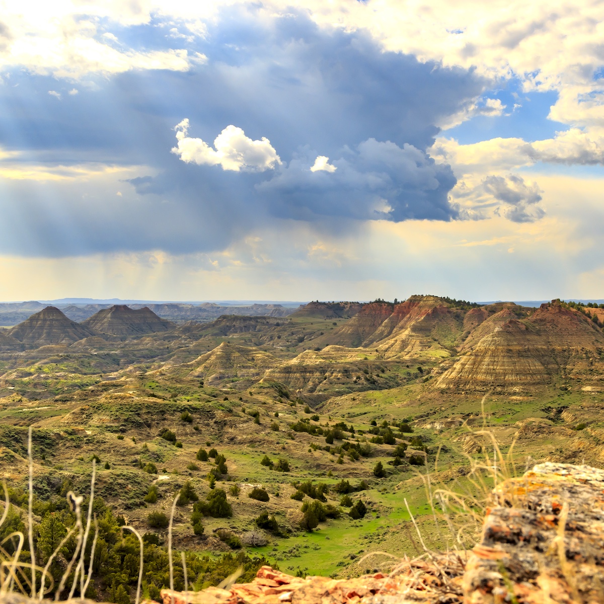
Next, head to the southeastern outskirts of Glendive to explore Makoshika State Park and its remarkable badlands formations — “Makoshika” (pronounced muh-KOH-shih-kuh) is a variant spelling of a Lakota phrase that translates to “bad land” or “bad earth.” A variety of hiking trails wind through the striking landscape, where wind and water erosion have sculpted caprocks, natural bridges, pinnacles, pedestals and fluted hillsides and helped to reveal dinosaur remains — the park is a site on the Montana Dinosaur Trail. Ten dinosaur species have been discovered at Makoshika, including T. rex, Edmontosaurus and the rare Thescelosaurus. You can see partially uncovered hadrosaur vertebrae in a hillside on the 1.5-mile Diane Gabriel loop trail, and the park’s visitor center features a triceratops skull in addition to other dinosaur remains and badlands interpretive displays. Makoshika State Park is Montana’s largest state park, and offers lots of activities beyond hiking and dinosaurs. Visitors will find scenic drives, a disc golf course, an archery range, a picnic area and campgrounds, and some trails can be used for biking and horseback riding. And the park’s allure only heightens when the sun sets — a site on Montana’s Trail to the Stars, it’s an absolutely breathtaking place for stargazing.
From Makoshika State Park, you’ll once again follow the path of the Yellowstone River, this time heading west on I-94 to Terry, the county seat of Prairie County. There’s great fishing to be had (for the likes of paddlefish, perch and walleye) on this stretch, so if you’re inclined, stop at the fishing access site in Fallon, about 9 miles before Terry. In addition to fishing, it’s a great spot to hunt for Montana moss agates, which are only found on the banks of the Yellowstone. In Terry, stop at Prairie Unique, a shop — and unofficial visitor center — where you’ll find a wealth of Made in Montana goods, like gourmet treats, skin care items and gifts crafted from antlers. The kindly owners are a friendly source of local knowledge to boot. Enjoy an intimate perspective on turn-of-the-20th-century life in Terry and its surroundings in the photographs of Evelyn Cameron; you’ll find them at the Prairie County Museum and Evelyn Cameron Gallery and across the street at the Evelyn Cameron Heritage. Another spot to take in some Terry history is the Kempton Hotel, the oldest continuously operated hotel in Montana. Built by homesteaders and opened for business in 1902, it has hosted the likes of Theodore Roosevelt and Calamity Jane, and continues to welcome travelers to stay in updated rooms that still retain historic charm. For its part, Roy Rodgers Bar Grill & Casino in town welcomes burger enthusiasts as another Southeast Montana Burger Trail stop.
After your explorations in town, head to the Terry Badlands — a Bureau of Land Management Wilderness Study Area (WSA) — for another breathtaking dose of badlands terrain or opportunities for rock collecting and backcountry hunting. You can reach a stunning scenic overlook via State Secondary Highway 253 north of Terry for views that are spectacular both during the day and at night — the area’s dark skies make the Terry Badlands Overlook a phenomenal spot for stargazing, earning it a spot on Montana’s Trail to the Stars. You can also head west from Terry on Old Highway 10 (the frontage road) to access the Terry Badlands via the Calypso Trail, which delivers a panoramic view of rugged, untouched prairie that looks much like it would have more than a century ago. From the Calypso Trail you can access the Natural Bridges Trail, a short, moderate hike to hoodoos and natural bridge formations. Note that you should visit the rough WSA terrain only when the road is dry and in a high-clearance, four-wheel-drive vehicle.
Head out of Terry on S-253 going north. As you leave town, keep an eye out on the west side of the highway for an information kiosk about the Big Sky Back Country Byway — a north-south route between Wolf Point in the north and Terry in the south, linking the Missouri and Yellowstone rivers. The stretch of highway between Terry and Montana Highway 200 makes up the southern portion of the scenic byway. And scenic it is — the wide-open prairie landscapes interspersed with badlands features make the big sky here seem even bigger.
At MT-200, turn west and drive through a mesmerizing landscape of badland formations toward Jordan, a small ranching town that — with surrounding rangeland and numerous false-front buildings still standing from homestead days — retains an Old West feel. It’s also prime dinosaur fossil country — the world’s first identified T. rex was uncovered nearby in 1902. Be sure to visit the Garfield County Museum, a stop on both the Montana Dinosaur Trail and the Missouri River Country Talking Trail, to see a T. rex skull and a full-size cast of a triceratops skeleton discovered north of town. The museum also highlights the area’s homesteading days, with artifacts and replicas displayed inside and a jailhouse and schoolhouse on its grounds. The land around Jordan is home to antelope, elk, mule deer and whitetail deer as well as wild turkeys, sage grouse and waterfowl, making this a great hunting area. Anglers are in luck here too: The Hell Creek Recreation Area, north of town on Hell Creek Road and a Talking Point on the Missouri River Country Talking Trail, offers incredible fishing for walleye, northern pike and smallmouth bass on the Hell Creek Arm of Fort Peck Lake against a stunning backdrop of Missouri River breaks terrain (think buttes and higher-level land that "break" into steep slopes, canyons and ravines where they meet the river). Boating, biking, hiking, camping and wildlife watching are popular here, as is stargazing — this site on Montana’s Trail to the Stars boasts the darkest night sky rating possible. Note that the dirt road to Hell Creek can be very washboarded and will get muddy in wet weather to the point of being impassable. Travel when it’s dry.
From Jordan, continue your drive west on MT-200, the road rising and falling over the hilly prairie terrain and the occasional butte making an appearance. Keep an eye out to spot deer, elk and antelope as you approach Winnett, the county seat of Petroleum County, Montana’s least populous. Here, stretch your legs and check out the town’s historic buildings by following the historical Winnett Walking Tour.
Enjoy the wide-open vistas of gently rolling grassland for another 70 miles on MT-200 before arriving in Lewistown, the geographic center of Montana. This agricultural community is a true gem of outdoor recreation, thanks to the surrounding island mountain ranges, proximity to rivers and lakes, and a spring-fed stream — Big Spring Creek — that runs right through town. Big Spring Creek offers opportunities for year-round red-ribbon fly fishing. Montana Fish, Wildlife and Parks maintains six seasonal fishing access sites on the stream, and summer sees swimmers, tubers and kayakers flock to the water. Hikers, campers and wildlife watchers find much to enjoy in the national forest land in the nearby Little Belt and Snowy mountains, and the big game and birds that populate the area make for excellent hunting here, too.
The treasures in Lewistown don’t stop with recreation, either. Take in the beautiful architecture throughout Lewistown’s five historic districts and visit the Central Montana Museum to soak up some of the colorful local history — it traces Lewistown area history starting from the 1870s, highlighting some of the notorious characters of the past along the way. There are literal gems too — Lewistown is known for Yogo sapphires, which are mined only in nearby Yogo Gulch and prized for their naturally occurring cornflower-blue hue. You can find them in Lewistown shops.
Just 18 miles south of Lewistown, tucked into the Big Snowy Mountains, you’ll find Crystal Lake, a scenic hub of outdoor pursuits. Stay at the campground and take in a sky full of stars — Crystal Lake is a stop on Montana’s Trail to the Stars. There’s great fishing on the annually stocked, 45-acre lake itself, and non-motorized watercraft are allowed. Explore incredible trails — there are ones for hiking, biking and horseback riding — that range from a leisurely loop around the lake to the challenging Ice Caves Trail: an 11-mile round-trip hike that leads to jaw-dropping views (on clear days all the way to the Tetons 220 miles south) and permanent ice caves — limestone rock formations cold enough to have ice year-round. The happy medium option might be the 7-mile round-trip hike to Grandview Point that affords expansive views of the lake and adjacent canyons and mountains.
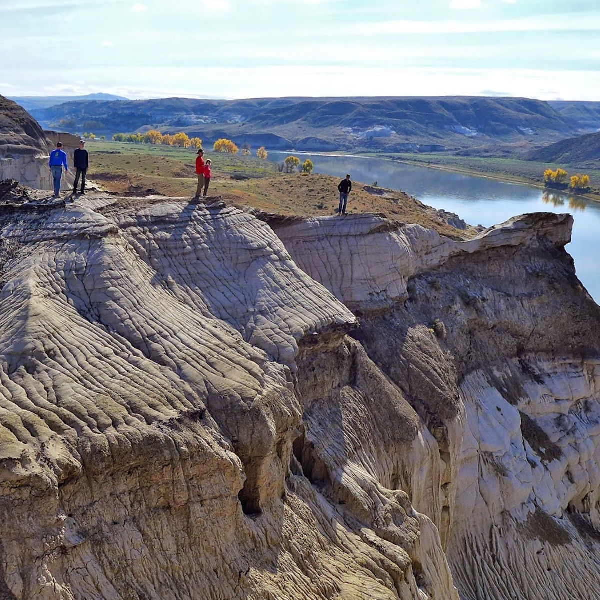
Set out from Lewistown heading north on U.S. Highway 191, passing between the Moccasin Mountains to the west and the Judith Mountains to the east before the road bends eastward. Look out for Route 236 and turn left to take it to Winifred, a rural town situated 30 minutes south of the Missouri River and 20 minutes east of the Judith River. With such proximity to these rivers, the terrain around Winifred is a picturesque mix of sweeping prairie land, timbered canyons and rugged breaks. The deer, antelope, elk and bighorn sheep that roam this landscape and the upland birds that inhabit the prairie draw both wildlife watchers and hunters here. Hunting guides can be found in Winifred itself, as can river outfitters — the town serves as a jumping-off point for float trips on the Missouri River through the part of it designated as the Upper Missouri River Breaks National Monument. “The Breaks,” as it’s known locally, stretches 149 miles from Fort Benton on U.S. Highway 87 to US-191 where the Fred Robinson Bridge crosses the river. The monument encompasses the terrain paralleling the Upper Missouri National Wild and Scenic River — water and land that hold Lewis and Clark, Native American and homesteader history and provide unrivaled recreational opportunities including float trips, hiking, camping, fishing and hunting. As the name suggests, the landscape is quintessential breaks topography — higher country that “breaks” into steep slopes, canyons and ravines where it meets the river. From Winifred, you can drive north to the river and cross via the historic McClelland Stafford Ferry (it operates seasonally) for a uniquely Montana experience.
From Winifred, head back south to US-191 then take it east, following it across gently rolling prairie as it turns north and reaches the Missouri River. The four-span steel girder Fred Robinson Bridge that enables passage across the river marks the end of the Upper Missouri River Breaks National Monument and is itself on the National Register of Historic Places. At its foot, the James Kipp Recreation Area — a Talking Point on the Missouri River Country Talking Trail and a Trail to the Stars site — provides convenient river access for fishing or putting in or taking out watercraft as well as a campground with scenic river views.
The western end of the 1.1-million-acre Charles M. Russell National Wildlife Refuge overlaps the eastern end of the Breaks, and after crossing the Robinson Bridge, you can take your first right to begin a self-guided auto tour with interpretive signage — it’s also a Talking Point on the Missouri River Country Talking Trail — that gives an up-close look at the refuge as it leads along the river to the Slippery Ann Wildlife Viewing Area. In September and October at dawn and dusk, you can observe the large numbers of elk that congregate in this spot during the rut (breeding season) — recent records document up to 500 animals gathering — and at night year-round, you can see a sky full of stars at this Trail to the Stars site. The gravel road then heads away from the river and into upland prairie and rangeland before emerging onto US-191.
Back on US-191 heading northeast, keep an eye out for the intersection just past mile marker 109. A right on the road leads to UL Bend National Wildlife Refuge, a remote area that’s part of the Charles M. Russell National Wildlife Refuge Complex — this “refuge within a refuge” is surrounded on three sides by both the Charles M. Russell National Wildlife Refuge and the Fort Peck Reservoir. UL Bend offers great opportunities for wildlife watching as it provides protection for an array of species, including eagles, owls, bighorn sheep, black bear, elk, and bobcat. Note that the road to the refuge can be quite rough — be sure to check weather and road conditions before visiting.
Taking a left at that US-191 intersection will bring you into Zortman, a historic gold-mining town — in 1904, its Ruby Gulch mine produced as much as $14,000 per day in bullion. You can learn more about Zortman’s days gone by on the Missouri River Country Talking Trail app. Today, visitors here will find a picturesque village — a simple but elegant white clapboard church sits above town on a grassy mountainside, overlooking the town’s architectural mix of log cabins, miner’s shacks and more modern buildings. They’ll also find that it’s a great base for hiking, hunting, camping, trail rides and gold panning. The nearby Little Rocky Mountains — or Little Rockies, as they’re affectionately called — provide the setting for some of those adventures. This group of buttes — Antoine Butte is the tallest at 5,720 feet — rises abruptly above the plain and can be seen from 75 miles away. For communities in the area, the Little Rockies are a treasured landmark.
Farther to the northeast on US-191 you’ll encounter Malta, a town with exceptional access to wildlife-centric recreation — even Lewis and Clark commented upon the abundance of animals here when they traveled through the area in 1805. Close by are the Charles M. Russell National Wildlife Refuge and the Bowdoin National Wildlife Refuge — a Missouri River Country Talking Trail Talking Point — both of which provide chances for deer, antelope, elk and upland game bird viewing and hunting in pristine wilderness. Fishermen will find opportunities to catch walleye, paddlefish, trout and other species at the nearby Milk River, Nelson Reservoir — another Talking Point on the Missouri River Country Talking Trail — and even local ponds.
Interested in wildlife of the prehistoric variety? Malta has you covered there, too. The town boasts two museums that are stops on both the Montana Dinosaur Trail and the Missouri River Country Talking Trail: the Great Plains Dinosaur Museum and Field Station and the Phillips County Museum. The Great Plains Dinosaur Museum features a wealth of fossils, from plants, turtles and crocodiles to Jurassic and Cretaceous dinosaurs including triceratops, stegosaurus and the horned Maltaceratops. A real treasure here is “Leonardo,” a mummified duck-bill Brachylophosaurus canadensis so well-preserved that fossilized skin covers the body (and reveals the dinosaur had small scales of polygonal shape). While other mummified dinosaurs have been discovered, Leonardo is the most complete. At the Phillips County Museum, see a 33-foot-long, 95% complete Brachylophosaurus along with other dinosaur fossils and get a sense of Malta’s more recent history through exhibits on Native Americans, cowboys and outlaws, and pioneer life and through the historic H.G. Robinson House: a mail-order home that was originally constructed on the prairie in 1898 and now sits on museum grounds.
Set out from Malta going east on Old U.S. Highway 2, and shortly after leaving town you’ll come to Bowdoin National Wildlife Refuge. Established in 1936, this 15,551-acre migratory bird refuge features a mix of saline and freshwater wetland within a grass prairie region and provides habitat for waterfowl, shore birds, birds of prey and songbirds as well as beaver, muskrat, coyote, white-tailed deer and pronghorn antelope. Explore the refuge and see the abundant wildlife by driving the refuge’s 15-mile self-guided auto tour. In the fall, bird hunting is permitted in designated areas.
Old U.S. Highway 2 will merge into U.S. Highway 2 east of the refuge, and the road will wind through a beautifully remote prairie landscape. Outside of Glasgow, take another opportunity to experience wildlife in its natural surroundings at the Bitter Creek Wilderness Study Area. Here you can view wildlife, hike, backpack, camp and hunt. Hop back on Highway 2 and just a little farther down the road, you’ll reach Glasgow. A small town in a lesser-visited part of Big Sky Country, Glasgow refers to itself as “the middle of nowhere” — tongue firmly in cheek, of course. Check out the Valley County Pioneer Museum’s eclectic exhibits on the Indian cultures that have historically called this area home, the construction of the Fort Peck Dam, Montana military history, early 20th-century homestead and cowboy life and the railroad, not to mention a collection of more than 200 wildlife mounts. And speaking of wildlife, visitors to the Children’s Museum of Northeast Montana and its hands-on arts and science exhibits can view the taxidermy collection of animals from around the world that make up the museum’s World Wildlife Experience. You can learn more about the Bitter Creek Wilderness Study Area, the World Wildlife Experience and both museums on the Missouri River Country Talking Trail app.
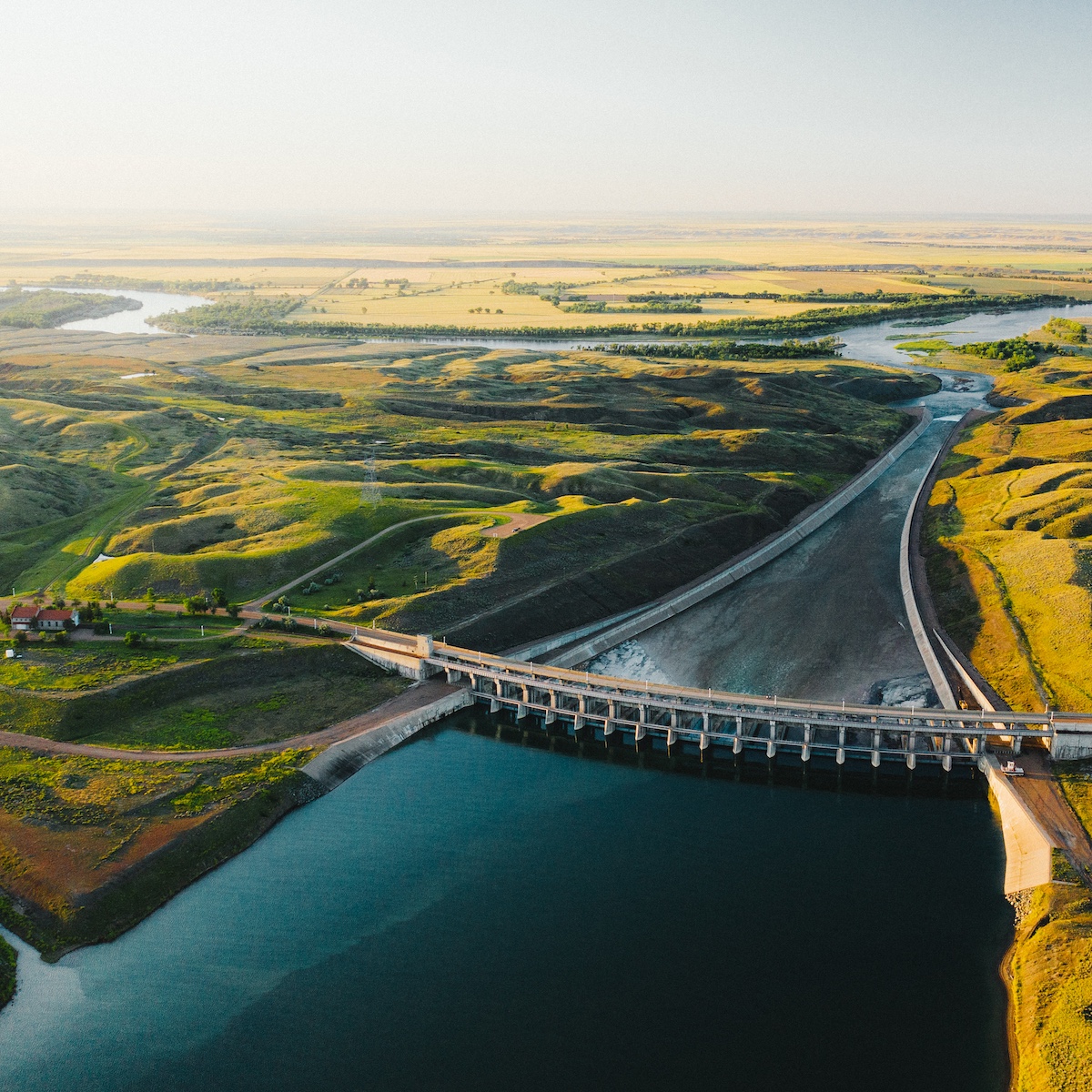
From Glasgow, it’s just a short jaunt to the southeast on Montana Highway 24 to reach neighboring Fort Peck and its rich mix of cultural and historical sights and recreational opportunities — many of which are Missouri River Country Talking Trail Talking Points. Make the Fort Peck Interpretive Center your first stop to explore exhibits on the history of Fort Peck Dam — the largest hydraulically filled dam in the U.S. — and on the area’s natural history and wildlife. That includes dinosaurs: The center, a Montana Dinosaur Trail site, is home to both a life-size model and a skeleton cast of Peck’s Rex, a T. rex found just 20 miles away, as well as other dinosaur fossils. A wildlife exhibit and two freshwater aquariums — the largest in Montana — highlight the land animals and fish found on the Charles M. Russell National Wildlife Refuge and in Fort Peck Lake and the Missouri River. Next, head to the beautiful Fort Peck Summer Theatre, a true gem of Northeast Montana and the state as a whole. Built as a movie house in 1934, its sound construction and craftsmanship — and the tireless preservation efforts of the Fort Peck Fine Arts Council — mean that it still stands today and hosts a summer series of stage productions.
Outdoor recreation here centers around Fort Peck Lake, which is completely bordered by the Charles M. Russell National Wildlife Refuge, the second-largest national wildlife refuge in the lower 48. The reservoir — created by Fort Peck Dam — is Montana’s largest body of water, with a length of 134 miles and more shoreline than the coast of California. Six recreation areas, including the Fort Peck Lake Reservoir and Recreation Area, can be found around the lake and offer excellent swimming, camping, hunting, boating and year-round fishing — walleye, northern pike, paddlefish, sauger and lake trout are just a few of the species that will keep anglers busy. The tucked-away Pines Recreation Area rewards intrepid travelers who navigate the dirt road to get there with serene scenery, great photo opportunities and, if you decide to camp, incredible stargazing — it’s a stop on Montana’s Trail to the Stars.
Drive south on MT-24 to depart Fort Peck, but don’t miss the chance for some incredible views on your way out of town. On the Fort Peck side of the river, check out the Lewis and Clark Overlook, complete with interpretive signage and a picnic area. After crossing the Missouri River on MT-24, take the short detour to the Milk River Observation Point — one of the highest spots in northeast Montana and the place where Lewis and Clark stopped in 1805 and observed the confluence of the Missouri and Milk rivers — and take in the awesome sight of the rivers and of Fort Peck and the lake spread out below. You can find out more about each of these two vantage points on the Missouri River Country Talking Trail app.
Return to MT-24 and enjoy the scenery of hills, coulees and badlands as you make your way to MT-200. Turn east and follow the road through gently rolling plains and grassland to Circle, a farming and ranching community at the crossroads of Montana Highway 13 and MT-200 in McCone County — a Talking Point on the Missouri River Country Talking Trail. Stop into the McCone County Museum — you’ll know it by its quirky collection of concrete dinosaurs outside. The small-town museum focuses on the area’s homesteading history and houses more than 10,000 artifacts in its exhibits and onsite historic structures.
Continue east on MT-200 from Circle, a route with far-reaching views of peaceful hills and hints of badlands terrain as you make your way toward Sidney, passing through country known for big game and upland bird hunting. You’ll soon come to Richey, a small but proud farming and ranching town. Richey celebrates its rural heritage with its own museum of local history — the Richey Historical Society & Museum highlights homesteading history through artifacts and six buildings with strong historical significance to the town — and by hosting events like the Richey Rodeo, an annual highlight on the community’s calendar for nearly 70 years.
When MT-200 intersects with MT-16, turn north to return to Sidney. End your Montana journey where it began, just like Lewis and Clark — the explorers reunited in August 1806 at the confluence of the Missouri and Yellowstone rivers near present-day Sidney after traveling separately across what would become Montana in their return trip — and celebrate your own successful Montana voyage of discovery.

Great Wide Open road trips intersect with a handful of engaging Montana trails — the Montana Dinosaur Trail, Montana's Trail to the Stars, the innovative Talking Trail app and the Southeast Montana Burger Trail — and our itineraries note when a point of interest is a site on one of them. These trails enrich your travel experience in Montana, highlighting places where you can learn about dinosaurs, listen to stories of local history, nature and culture, find great spots for incredible stargazing or discover some truly remarkable burgers. Visit each trail's website to learn more.